The Atmospheric Environment Remote Sensing Innovation, Research, and Development Center (R&D Center) adopted a self-developed hyperspectral remote sensing algorithm for atmospheric pollutants, and successfully captured a large amount of sulfur dioxide (SO2) plume distribution produced by the Hunga Tonga-Hunga Haʻapai (Tonga) volcanic eruption in January 2022.
On January 14, 2022, the Tonga volcano, a submarine volcano in the South Pacific (20.54°S, 175.38°W), erupted with massive volcanic gas and ash plumes to high levels. On January 15 and 17, 2022, it erupted again, triggering a tsunami that affected Tonga and surrounding countries.

True color map of Tonga volcanic eruption from Himawari-8 observation
The Environmental Monitoring Instrument-2 (EMI-2) is onboard the GaoFen-5 (GF-5)02 satellite, which was launched on September 7, 2021. The equator ascending crossing time of GF-5 02 is around 10:30 a.m. local time (LT). It can obtain major pollutant gases in the global atmosphere, effectively serving the coordinated control of PM2.5 and O3, the synergy of pollution reduction and carbon reduction, and enhance China’s international voice in global environmental issues right. The R&D Center provided the SO2 distribution in areas affected by the Tonga eruption based on EMI-2 observations from January 13 to 17, 2022. The results are as follows:
1. On January 13 (Universal Time Coordinated, UTC): EMI-2 provided the measurements of SO2 column several hours after the Tonga volcano eruption at 4:20 a.m. LT on January 14. The SO2 concentrations were higher around the crater and lower near the crater.
2. On January 14 (UTC): Under easterly winds, the SO2 plume from the Tonga volcanic eruption migrated to the west and diluted.
3. On January 15 (UTC): EMI-2 captured high concentrations of SO2 again, as the Tonga volcano erupted for the second time at 5:10 p.m. LT on January 15.
4. On January 16 (UTC): the Tonga volcano erupted for the third time, SO2 plume moved further westward and EMI-2 retrievals suggested SO2 concentrations as high as 40 DU.
5. On January 17 (UTC): SO2 plume from the Tonga eruption continued to drift westward. EMI-2 observed two relatively intact plumes, and the boundary between the two plumes became more distinct.
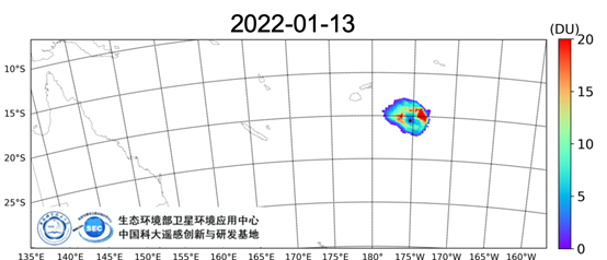
SO2 distribution from EMI-2 observations on January 13 (UTC) (Image by R&D Center)
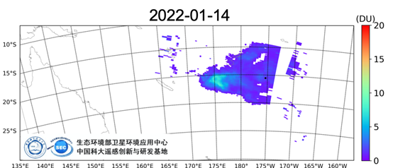
SO2 distribution observed on January 14 (UTC) (Image by R&D Center)

SO2 distribution observed on January 15 (UTC) (Image by R&D Center)

SO2 distribution observed on January 16 (UTC) (Image by R&D Center)

SO2 distribution on January 17 (UTC) (Image by R&D Center)
As of January 17, the total SO2 emissions produced by Tonga were about 916-940 kt. Compared with all recorded eruptions in the 21st century, Tonga's current emissions could be among the top. Furthermore, the SO2 emissions from the Tonga eruption to date had been much larger than the annual emissions from each anthropogenic hotspot in 2019, except for the emissions from the Norilsk smelter site in Russia in 2019.
The R&D center is jointly established by the School of Engineering Sciences at the University of Science and Technology of China (USTC) and the Satellite Application Center of Ecology and Environment of Ministry of Ecology and Environment of the People’s Republic of China (MEE). The USTC Atmospheric Environment Remote Sensing Team has been engaged in the development and research of remote sensing monitoring algorithms and hardware for atmospheric pollution components and greenhouse gases. The quality of the retrieval products is on par with the most advanced satellites in the world. The SO2 plume observation of the Tonga volcano based on EMI-2 shows that Chinese hyperspectral satellites can play an important role in the monitoring of global emergencies.
(Written by Professor LIU Cheng, edited by JIANG Pengcen, USTC News Center)