The plum rain is a persistent and extensive rainfall phenomenon that frequently occurs in East Asia during summer, primarily affecting regions along the latitudes of the middle and lower reaches of the Yangtze River in China to the Kyushu Island in Japan. In 2020, a record-breaking "violent plum rain" hit China and Japan, causing severe damage to the lives and production activities of the local residents. There is an urgent need to improve the accuracy of subseasonal forecasts of such event.
Recently, a team led by Prof. ZHAO Chun and Prof. AN Hong from the University of Science and Technology of China (USTC) conducted a one-month subseasonal forecast experiment using a self-developed global convection-permitting model based on China's Sunway supercomputer, accurately capturing the rainband of the extensive 2020 plum rain events in Japan. Their work was published in Environmental Research Letters.
The research team had previously developed an integrated atmospheric model across scales (iAMAS) on the Sunway supercomputer, and optimized the iAMAS algorithms according to Sunway’s hardware characteristics to accelerate computational speed and overcome bottlenecks in massive data reading and writing, enabling monthly forecasts at a global convection-permitting scale (3km resolution).
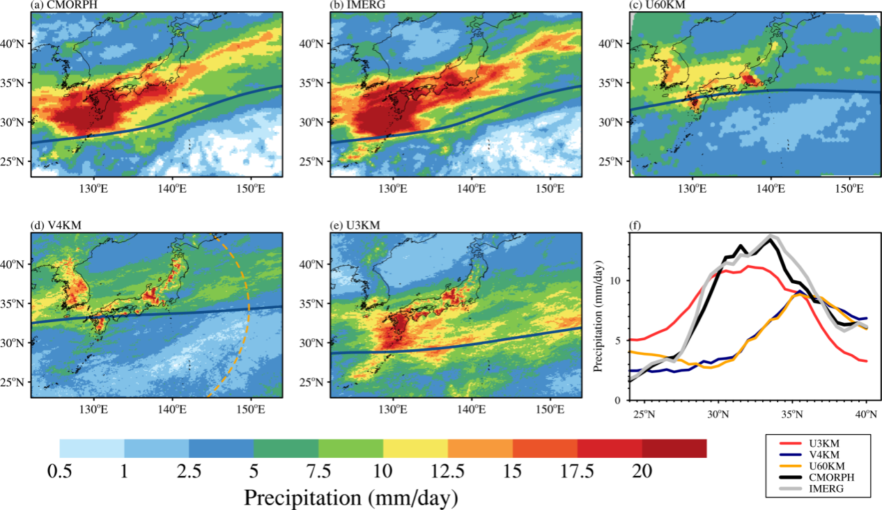
Through conducting a series of monthly forecasts with different resolutions, the team explored the predictability of the 2020 plum rain. They found that when using a global 60km low-resolution forecast, there was a significant northward shift in the predicted rainband, which could not be addressed even by refining the resolution to the convection-permitting scale. Further analysis revealed that at coarser resolutions, the Western North Pacific Subtropical High (WNPSH) expanded, causing the rainband to shift northward and weaken.

Predictions of monthly mean precipitation by models with different resolution. (Image by GU Jun et al.)
Further research found that the global convection-permitting model could effectively capture deep convection in the equatorial region and reasonably simulate the equatorial rainfall processes and circulation patterns in Western Pacific, aligning well with observational data. This equatorial rainfall processes and circulation patterns reflect the intensity and position of WNPSH and then influence the circulation in mid-latitudes, including its subsidence and uplift positions, which enabled the researchers to successfully predict the intensity and location of the plum rain event.

Schematic of the teleconnection between plum rain in Japan with tropical rainfall. (Image by GU Jun et al.)
Paperlink: https://iopscience.iop.org/article/10.1088/1748-9326/ad71e2
(Written by CAI Guoyuan, edited by ZHANG Yihang, USTC News Center)