At the end of July 2023, an extreme heavy rainfall suddenly struck North China (23.7 event), causing severe flood disasters in Beijing, Hebei, and other places, resulting in significant casualties and property losses. How was this record-breaking rainstorm formed? Is it only the combined effect of the Typhoon Doksuri and the terrain?
Intrigued by this question, a research team led by Prof. ZHAO Chun from the University of Science and Technology of China (USTC) of the Chinese Academy of Sciences conducted global variable resolution regional encrypted numerical simulations and climate attribution analysis, revealing a previously overlooked key factor: the Mongolian Plateau (MP) region. This research result was published in Geophysical Research Letters.
The study pointed out that in the context of global warming, not all regions were experiencing synchronous and uniform temperature increases. While among them, the MP was a hotspot.
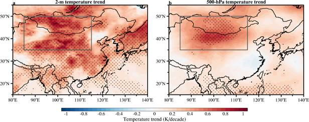
The anomalous warming trend in air temperatures on the MP. (Image by USTC)
In MP, the rate of temperature increase in recent decades had exceeded three times the global average, with the temperature rise far surpassing the surrounding areas, breaking through the tipping point.
It was found that MP significantly catalyzed and amplified the extreme rainfall in North China. The abnormal climate in this region not only directly affected the local ecology, but also served as a significant source of sand and dust weather in our country. However, its impact might go far beyond that.
In terms of total rainfall and impact range, this event significantly surpassed many extreme rainfall events in the history of North China.
The extremeness of the 23.7 event was beyond imagination. The 744.8mm of rainfall observed in Beijing hit the record over the past 140 years. The maximum rainfall in Lincheng County, Hebei Province, even reached 1003.4mm, equivalent to the local average rainfall of two years being poured down in just three days.
In order to understand how the MP affected the North China region hundreds of kilometers away, researchers utilized their developed integrated At-mospheric Model Across Scales (iAMAS) model. Together, with the support of the China’s new Sunway supercomputer, researchers precisely simulated and reproduced the extreme rainfall process.
The simulation results were highly consistent with actual observations in terms of rainfall distribution, intensity, and spatiotemporal evolution.
Based on high-precision simulations and the storyline climate attribution principle, researchers designed comparative experiments and found that among the many factors leading to the extreme rainfall, the abnormal rapid warming trend of the MP was the exact hidden hand.
The rapid warming of the air (middle atmosphere) over the MP acted like a "heater", promoting the formation of an abnormally strong and stable high-pressure system in the region. The air had developed and connected with the Western North Pacific Subtropical High. In the end, a high-pressure system over the North China region was formed.
The system hindered the remnant circulation of the Doksuri carrying water vapor from continuing its northward or eastward journey, trapping it for a long time in the region in front of the Taihang Mountains (TM) in North China.
The intercepted water vapor, under the continuous uplift effect of the TM terrain, was forced to converge and rise, leading to rainfall to be concentrated and poured in a narrow area for a long time, ultimately resulting in a record-breaking extreme rainstorm disaster.
The results unveiled that the links between climate impacts in different regions may be more complex and subtle than we thought, especially in a context of ongoing global warming with heterogeneous regional temperature increases.
Understanding this teleconnection mechanism is crucial for enhancing the predictive and warning capabilities of extreme weather and climate events.
Paper link: https://doi.org/10.1029/2024GL113737
(Written by Huang Rui, USTC News Center)